Engineering Urbicide
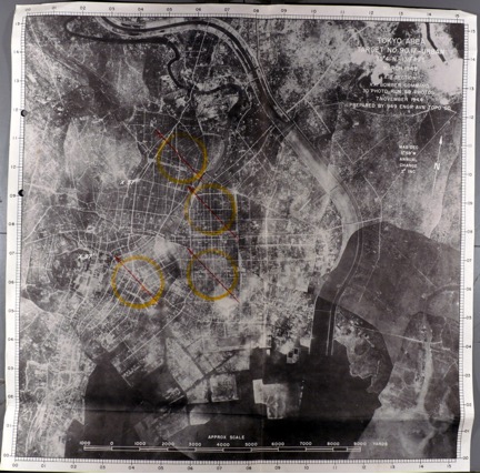
But while American audiences tapped their feet to these calls for retribution from the air, a growing cadre of engineers, chemical scientists, and intelligence officers began research into the campaign to actually achieve this destruction. Many different planning documents offer insight into the process whereby the US military-industrial-academic complex facilitated the shift towards indiscriminate firebombing of urban zones. As early as 1942, for example, cartographers in the OSS began to precisely demarcate Tokyo’s vulnerable fire zones—a point perhaps best evidenced in OSS Map no. 877.
While the style and utility of this visual intelligence varied considerably, one factor remains consistent throughout geo-spatial representations of Tokyo used to plan the raids: an abiding fixation on the Shitamachi district of the northeast. Planners took particular interest in the most densely built-up and inhabited Asakusa District, where plans estimated an average of 40,000 persons per square kilometer.
Architects and engineers doubtless had just this district in mind when, in 1942, they erected a model Japanese “worker's quarters” at the Dugway Proving Ground in the desert of Utah in order to understand how best to burn it to the ground.
Thus, at the very moment that USAAF commanders were publicly affirming their commitment to the strategic doctrine of high altitude precision bombing—and condemning the use of incendiaries in Europe—strategists, planners, and scientists were vigorously studying their application to Tokyo and its built environment (Plung 2018).