This path was created by Michitake Aso. The last update was by Kate McDonald.
Orientation: Cartographies of Northern Vietnam
1 2020-08-02T12:52:47-04:00 Michitake Aso c957806dd05559bbe07c540e9ab4cd46aae194d3 35 16 The history of cartographic representation of northern Vietnam plain 4801 2021-10-05T10:16:05-04:00 China, Korea, Japan, Vietnam 1800-1954 Michitake Aso Kate McDonald 306bb1134bc892ab2ada669bed7aecb100ef7d5fThe question of how northern Vietnamese culture and society have interacted with those of East Asian is a long standing one. Scholars such as Alexander Woodside, Emmanuel Poisson, and Liam Kelley have analyzed textual and administrative influences that China had on Vietnam. Jamie Anderson and Brad Davis have looked at the borderlands between Northern Vietnam and Southern China. Michele Thompson has written about exchanges of plants, materia medica, and medical knowledge as well as the ecological zones of this region. And Li Tana and others have looked at the watery space of the Gulf of Tonkin.
Studies placing the Vietnamese of the north in their Southeast Asian context are fewer. Christopher Goscha has studied how communist party members and revolutionaries circulated throughout Southeast Asia. He has also looked at the debate over Vietnam versus Indochina in revolutionary geographies. And Christian Lentz has recently placed the world historic battle at Điện Biên Phủ in its local context.
This side path considers the place of northern Vietnam through its representation in cartographic maps. The procession of pages suggests a Vietnamese imaginary initially shaped by a Sinosphere spatial imaginary. Then, reoriented by colonial experience, Vietnamese intellectuals began to place themselves in maps of France and its colonies. Finally, the nation, and the Vietnamese geobody, have played their dominate roles in forming spatial imaginaries. While the cartographies shown in the path all continue to coexist, the trend through the twentieth century among Vietnamese has been towards a Viet-centric spatial imagination. Empires remain but they are for the most part absent from cartographic representation—with the exception perhaps of the Vietnamese empire.
As you consider mapping and mobilities, consider the relationship of these two processes. They may seem to exist in tension: maps define and solidify, while mobility destabilizes. Yet, the two processes have been inextricably intertwined. On the one hand, maps could not be created without movement and exploration. There was the physical movement of the explorer and the material and symbolic flows that happened through knowledge networks. Starting in the colonial era, airplanes aided this mapping. They also created aerial views that, as Sakura Christmas and David Fedman note, elided the violence they enabled. On the other hand, understanding, and therefore engaging in, movement was difficult if not impossible without some kind of map. These maps could be official, state created maps or they could be unofficial and personal, from individual mental maps to communal song lines to airplane routes. So mapping and movement have been two complementary, intertwined processes.
This page has paths:
- 1 2019-11-18T15:48:28-05:00 Kate McDonald 306bb1134bc892ab2ada669bed7aecb100ef7d5f Mapping Invasion: Vietnamese Responses to Biological Warfare During the First Indochina War Kate McDonald 57 Michitake Aso image_header 4897 2021-10-05T10:02:00-04:00 Tonkin 22.0000, 105.0000 Hanoi 21.00311, 105.82014 Chiem Hoa 22.159952, 105.273503 Hue 16.469155, 107.576461 Thanh Hoa 19.809090, 105.783020 Beijing 39.92284, 116.40120 Pyongyang 39.019282, 125.752754 Northern Vietnam 21.814229, 105.212900 Dien Bien Phu 21.392808, 103.019702 Paris 48.8667, 2.3333 Phu Tho 21.42197, 105.22969 Bac Giang 21.28199, 106.19747 Cao Bang 22.66663, 106.26398 Hai Ninh 20.97186, 106.80353 Lang Son 21.8537, 106.76151 Vinh Phuc 21.36088, 105.54743 Tuyen Quang 21.77672, 105.22801 Yen Bai 21.71676, 104.89858 Thai Nguyen 21.56715, 105.8252 Bac Ninh 21.17817, 106.07102 Ha Giang 22.80255, 104.97844 Quang Yen 20.83053, 106.675175 21.589283, 105.828573 Frederick 39.441169, -77.424356 1946-1954 Michitake Aso Ho Chi Minh Tôn Thất Tùng Vietnamese Patriotic Hygiene Movement Kate McDonald 306bb1134bc892ab2ada669bed7aecb100ef7d5f
Contents of this path:
- 1 2020-07-26T09:41:08-04:00 Michitake Aso c957806dd05559bbe07c540e9ab4cd46aae194d3 Physical and Cultural Cartographies 48 Background Information for northern Vietnam plain 2021-10-05T10:20:14-04:00 Red River Delta 1900-2020 Michitake Aso Kate McDonald 306bb1134bc892ab2ada669bed7aecb100ef7d5f
- 1 2020-07-28T09:40:04-04:00 Michitake Aso c957806dd05559bbe07c540e9ab4cd46aae194d3 Sinosphere Cartographies 28 Background Information for northern Vietnam plain 2021-10-05T10:26:25-04:00 1800-1900 Kate McDonald 306bb1134bc892ab2ada669bed7aecb100ef7d5f
- 1 2020-07-28T09:44:19-04:00 Michitake Aso c957806dd05559bbe07c540e9ab4cd46aae194d3 Northern Vietnam as Borderland 40 Background Information for northern Vietnam plain 4802 2021-10-05T10:30:31-04:00 Tonkin 22.0000, 105.0000 1894-2000s Michitake Aso Kate McDonald 306bb1134bc892ab2ada669bed7aecb100ef7d5f
- 1 2020-07-28T09:41:20-04:00 Michitake Aso c957806dd05559bbe07c540e9ab4cd46aae194d3 Vietnamese Geobody 21 Background Information for northern Vietnam plain 2021-10-05T10:32:39-04:00 Michitake Aso Kate McDonald 306bb1134bc892ab2ada669bed7aecb100ef7d5f
- 1 2020-07-28T09:42:06-04:00 Michitake Aso c957806dd05559bbe07c540e9ab4cd46aae194d3 Hanoi and Thai Nguyen 19 Background Information for northern Vietnam plain 2021-10-05T10:38:09-04:00 Michitake Aso Kate McDonald 306bb1134bc892ab2ada669bed7aecb100ef7d5f
- 1 2020-07-31T17:32:20-04:00 Michitake Aso c957806dd05559bbe07c540e9ab4cd46aae194d3 Cartographies of Revolution 19 Background information for northern Vietnam plain 2021-10-05T10:41:07-04:00 Michitake Aso Kate McDonald 306bb1134bc892ab2ada669bed7aecb100ef7d5f
This page has tags:
- 1 2020-09-11T17:40:32-04:00 Kate McDonald 306bb1134bc892ab2ada669bed7aecb100ef7d5f Mapping Kate McDonald 1 Third-Level Tag plain 2020-09-11T17:40:32-04:00 Kate McDonald 306bb1134bc892ab2ada669bed7aecb100ef7d5f
This page is referenced by:
-
1
2019-11-18T15:48:28-05:00
Mapping Invasion: Vietnamese Responses to Biological Warfare During the First Indochina War
57
Michitake Aso
image_header
4897
2021-10-05T10:02:00-04:00
Tonkin
22.0000, 105.0000
Hanoi
21.00311, 105.82014
Chiem Hoa
22.159952, 105.273503
Hue
16.469155, 107.576461
Thanh Hoa
19.809090, 105.783020
Beijing
39.92284, 116.40120
Pyongyang
39.019282, 125.752754
Northern Vietnam
21.814229, 105.212900
Dien Bien Phu
21.392808, 103.019702
Paris
48.8667, 2.3333
Phu Tho
21.42197, 105.22969
Bac Giang
21.28199, 106.19747
Cao Bang
22.66663, 106.26398
Hai Ninh
20.97186, 106.80353
Lang Son
21.8537, 106.76151
Vinh Phuc
21.36088, 105.54743
Tuyen Quang
21.77672, 105.22801
Yen Bai
21.71676, 104.89858
Thai Nguyen
21.56715, 105.8252
Bac Ninh
21.17817, 106.07102
Ha Giang
22.80255, 104.97844
Quang Yen
20.83053, 106.675175
21.589283, 105.828573
Frederick
39.441169, -77.424356
1946-1954
Michitake Aso
Ho Chi Minh
Tôn Thất Tùng
Vietnamese Patriotic Hygiene Movement
This module analyzes Vietnamese responses to the French military's possible use of biological warfare during the First Indochina War (1946-1954). Beginning in 1952, the Việt Minh, the anti-colonial popular front forces led by Ho Chi Minh, collected reports of French airplanes releasing powders, worm-infested leaflets, and other strange substances over Việt Minh-controlled territory in and around the Red River Delta. These reports assumed that the strange substances were biological weapons, including insects and microbes meant either to sicken or kill humans directly or to infect plants and animals and threaten the Vietnamese food supply. Such reports lasted until at least the battle of Điện Biên Phủ in 1954.
This module argues that Vietnamese responses to biological warfare were inherently spatial. They depended, for example, on mapping information gathered from dispersed sources, from conferences held in China to surveys of farmers in the Red River Delta. Moreover, this intellectual geography overlapped, and existed in tension, with a political geography of civilizations, regions, and nation-states, an emotional geography of fear, and a medical geography that linked airplanes, environments, microbes, and humans. Unpacking the (non) event of biological warfare shows, in turn, how responses to biological weapons had complicated effects on Vietnamese spatial imaginaries. From a Vietnamese perspective, germ warfare helped place northern Vietnam in reconfigured Sinosphere and borderland relationships and created newer nationalist and revolutionary worlds. In other words, this period shows a mix of old and new maps being used to understand new hybrid environments of microbial, human, and machine movement.
To make maps useful for combatting biological warfare, the Việt Minh had to understand conditions in local places at specific moments. Moving from generalized knowledge about the Sinosphere to specific knowledge about places in the Red River Delta took hard work. This module seeks to trace and, in a limited way, reproduce the labor needed to map the mobilities and immobilities of invasion. In other words, the structure of this module mimics the movement from general to specific, and old to new, and the intellectual and physical labor needed to make such a move. Such a structure encourages users to reflect on how historical actors moved between scales that were different in quantity and in quality, shifting between different geographic scales—global, regional, national, and local—and different types of maps—civilizational, emotional, and biogeographical. In other words, this module examines what certain Vietnamese thought about biological warfare and to explain what those actors thought with and how these structures changed over time.
This module is divided into three pathways, each of which explores a different theme in biological warfare. Path A is called “Learning from the Korean War.” It encourages users to explores communist charges of biological warfare in North Korea and northeast China leveled against the United States military. It examines notes from a Vietnamese delegation to an international conference about biological warfare along with Chinese posters produced as part of a patriotic hygiene movement. A side path shows how northern Vietnam has been incorporated into various spatial imaginaries. Path B is called “Surveying Northern Vietnam.” It encourages users to explore biological warfare in northern Vietnam during the First Indochina War. Drawing from reports of the Committee to Prevent Germs, this path traces the steps that the Việt Minh took to produce knowledge about biological warfare. A side path explores the life of one of the committee's leaders, the famous Vietnamese medical doctor Tôn Thất Tùng. Finally, this path offers a Google map of a few suspected incidents of biological weapons use drawn from the committee's work and other Việt Minh reports. Path C is called “Preparing for Biological Warfare.” Such efforts included included producing and distributing a pamphlet meant to popularize knowledge about the history of American and Japanese use of biological weapons. This pamphlet sought to mobilize domestic Vietnamese audiences to fight. It aimed as well to show international audiences the Vietnamese connections to the communist revolutions that had taken place in China and Korea. Finally, the Việt Minh organized a Vietnamese Patriotic Hygiene Movement modeled on the Chinese Patriotic Hygiene Movement.
Click here for a list of references for this module, which is also available from the module's Conclusion page.
-
1
2020-08-02T13:22:38-04:00
Invasions in the Sinosphere
24
Situating biological invasion in the larger history of invasion in Vietnamese society
plain
43509
2021-10-05T10:09:37-04:00
Michitake Aso
Việt Minh
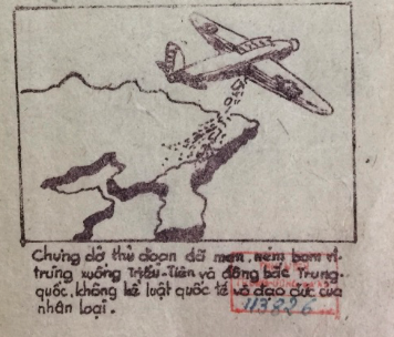
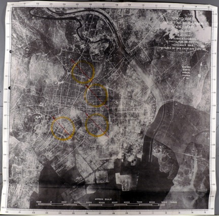
During the Cold War, what was a biological invasion and how it would happen were questions that caused anxiety and fear. This type of warfare involved the intentional use of microbes, and the living and non-living vectors that carry them, to weaken or kill humans considered enemies. In the context of total war, biological warfare was also directed at the animals and plants that helped sustain those people. And by ending stories, biological warfare could, no less than the firebombing of Tokyo analyzed by David Fedman, annihilate place.
The fear of invasion has been explored in the US context but less so for other societies, especially in the “Third World,” which was the site of so many types of invasions. Traditional understandings of invasions, or unwanted border crossings, in Vietnamese society have revolved around humans including Mongols, Chinese, and French armies. But biological warfare techniques developed in the twentieth century meant that non-human nature, and the environment itself, could become an invasive threat. Việt Minh medical doctors and cadre became concerned about insidious invasions that would go undetected until after it was too late to resist them and they had to grapple with several questions:
What were the geographies of invasion? At what scale could they happen? What would an invasion look like? How could an invasion be differentiated from “natural” processes? Who, and what, would invade? How, in short, could invasions be mapped? And then, perhaps most importantly, how could these invasions be stopped?
In order to start to answer these questions, the Việt Minh drew on, and modified, existing spatial imaginaries. After 1949 and the victory of the communists in China, Việt Minh leaders envisioned Vietnam rejoining a recreated Sinosphere world, this time linked not by Confucian culture but by communist party rule. In this Sinosphere world, a newly established PRC was at the center (though peripheral to the Soviet Union), with parts of Vietnam and Korea joined to this world. By the early 1950s, Japan and South Korea were under US control, and thus out of the communist Sinosphere. Not surprisingly, the Việt Minh turned to Chinese investigations in order to better understand potential biological warfare in Northern Vietnam. In addition to Vietnamese medical doctors and students traveling to China for study, the PRC held a conference in Beijing to present the evidence of US biological warfare in North Korea and Northeast China.
If you are unfamiliar with the historical geographies of East and Southeast Asia, you may wish to explore a side path on cartographic maps of Northern Vietnam. Otherwise, you can continue on the main path about biological warfare during the Korean War.
-
1
media/bs2.site.modulecollage.image2.001.jpeg
2021-04-27T17:43:03-04:00
Reorienting Our Scholarship
20
Guided Tour (4)
plain
2021-10-15T15:14:32-04:00
Kate McDonald
David R. Ambaras
Bodies and Structures 2.0 allows us as scholars and students to take ownership of our maps. As we wrote in an earlier essay, “The map is not a given. We map, and in doing so we produce knowledge. But we also produce fictions, and elisions. Ownership entails the responsibility to map in ways that align with the ethics of our scholarship” (Ambaras et al. 2019).
Owning our maps leads to ontological and epistemological “so whats” and “takeaways.” The first contribution of Bodies and Structures 2.0 is ontological. The critical geographic and spatial humanistic theory that helped us to frame this project has been in development for over forty years. We are, in other words, not the first to recognize the need for multivocal mapping, for liberating the map, and for provincializing cartographic rationalities (Corrigan 2015; Pearson and Shanks 2014; Pickles 2012; Winichakul 1997; Certeau 1984). What Bodies and Structures 2.0 offers is the visceral experience of multivocal mapping—the ability to encounter and analyze historical experiences in multiple spatialities, with frameworks provided by our editorial collective and / or that readers supply via the Lenses tool. In the words of John Corrigan, the site’s collaborative design “fosters intersections in research” and “complicate[s] the stories we can tell.” It provides students, scholars, and teachers a way of approaching the past that “leverages the open-endedness and the polyvocality of spatial humanities and the often surprising insights derived from that enterprise to create narratives that are more inclusive, that bridge gaps, that challenge familiar categories of space and time as historical constructs that privilege some voices and marginalize others” (Corrigan 2021). Bodies and Structures 2.0 uses collaboration and digital methods to demonstrate not just the rich possibilities that multivocal mapping offers, but also the essential need to write and think in ways that presume the multivocality of space and place.
Essential Situatedness: From Critique to Structure
Bodies and Structures 2.0 invites readers to stand certain in the essential situatedness of knowledge and experience about space and place. It asks scholars to attend not to the question of “what” is space and place, but rather “whose space” and “on what terms?” It precludes metonymies of scale—allowing a history of one province, one individual, or one culture to stand in for the whole. Instead, it posits a deep map of modern East Asia that both spans the entire globe and renders such a universalized spatiality impossible.
As in the case of our critiques of cartographic rationality, we are not the first to suggest that the borders of “Asia” or “modern East Asia” are porous, that the spatial experience of Asia is always emergent, or that the meaning ascribed to the regional framework has more to do with geopolitics than lived histories (see, e.g., Tagliacozzo, Siu, and Perdue 2015a, 2015b, and 2019; Ho 2017; Duara 2010; Lewis and Wigen 1997). Bodies and Structures provides a research environment in which these insights are the foundation, rather than the critique. For example, the site does not gather its many cartographic images under a tag called “Maps.” Instead, the site uses the tag “Mapping” to place cartographic representations and regionalizations within a melange of ways in which historical actors have made spatial differences meaningful. Bodies and Structures conducts a mapping operation that is less about identifying parcels of absolute space or plotting specific steps in an itinerary, and more about cognitively reframing our perception of the rhetorics and technologies used to produce modern East Asia as a certain kind of space amenable to specific operations of power. Mapping includes many examples of historical cartography (e.g., “Cartographies of Northern Vietnam”; “Aerial Innovations in Mapping”; “Surveying Empire”; “Capital Punishment”). But it also includes the practice of ascribing higher artistic value to the works of artists in Japan's inner territories in contrast to those of “settler-artists” working in colonized territories (“Model Works”), the construction of the Lingquan Temple in Taiwan as a site of fusion between Chinese and Japanese Buddhism (“The Lingquan Temple: Taiwanese Buddhism”), and a Chinese lithograph that visualizes the future and traces its passage from Paris to London to Shanghai (“The Trottoir Roulant”). We know that the cartographic map occludes in order to illuminate. “Mapping” illuminates and then asks what else we need to include.
Through its visualizations, tags, and opportunities for nonlinear reading, Bodies and Structures enables users to read across places and, in so doing, shift from thinking about map as a noun to thinking about mapping as always already a verb. In a similar fashion, Bodies and Structures 2.0 approaches “scale” as an act of situated knowledge making and human action rather than a matter of absolute geometry. By putting the tag “media” onto a cartographic map (via the Lenses tool), for example, we can consider how representations and imaginative geographies operating in a given locality might be connected to others. Rendering the same tag relationships as a list affords a different possibility for visualizing the site’s contents, in this case suggesting the different ways and scales at which spatial processes were constituted and experienced: e.g., from the air, on the printed page, and in gendered, embodied movements that included the consumption and manipulation of new material objects and technologies.
The coexistence or simultaneity of different ways of constituting and experiencing space and time underscores the need to approach scale critically when deep-mapping modern East Asian history. Used without reflecting on the rationality that produces it, scale naturalizes particular spatial structures (e.g., local, regional, national, and international; or micro, meso, and macro) as space itself (see, e.g., Howitt 1998). Multiple scales—if they are constituted within the same, unspoken rationality—do not necessarily produce a critical spatial history. In contrast, Bodies and Structures 2.0 uses the tag “Rationalities” to highlight the logics of space and time that distinguish one spatiality from another. Though they exist in the same time and place, the spatio-temporality of a spatial structure governed by a “vital rationality,” for example, differs significantly from one governed by a “territorial rationality.” In the former, the time that a given living being can survive determines distance, including the meaning of adjectives such as “near” and “far.” In the latter, the ability of the bureaucratic and social structures of the state to demarcate and manage territorial boundaries determines the difference between “here” and “there” or “domestic” and “foreign.” Significantly, the difference between rationalities is not necessarily one that can be defined through comparisons within categories. Instead, Rationalities shows that different spatial logics define space and time by prioritizing completely different categories.
Rationalities suggests that scales are worth analyzing as historical phenomena in their own right. Here, for example, Peter Thilly’s comparison of the spatial logic of Qing regional administration and that of the Jardine-Matheson opium network is instructive. Both coexist in the same locale, the same time and place. Yet both produce very different spatio-temporalities and concepts of scale. Likewise, Sakura Christmas and Michitake Aso show how scale in the history of “aerial zones” is made up of non-overlapping layers of knowledge, history, media, topography, and political networks. Each scale enables or constrains the ability of aerial photographers, in Christmas’s example, or Viet Minh anti-biological warfare activists, in Aso’s example, to achieve their goals. In her analysis of the oral histories of Okinawan migrants to Taiwan, Hiroko Matsuda shows how these “liminal” actors produced their own scalar relationships through a combination of topographical, network, territorial, and market rationalities, even as their physical and social locations were shaped by the scalar politics of metropolitan bureaucrats, sugar capitalists, and other actors. Together, the Bodies and Structures modules show how attention to encounters between and across scales generates grounded and situated analyses that bring the spatiality of “modern East Asian history” to life on as many terms as there are histories.
Conceptual Deep-Maps: “East Asia” in Multivocal Space
Deep-mapping East Asia, or any region, requires taking ownership of our maps by recognizing the inherent multivocality of space and mapping our analyses within that multivocal space and its situated relationships of scale. Bodies and Structures 2.0 shows that such multivocal analysis produces spatial histories that push far beyond the traditional objects of spatial historical analysis. “East Asia” in multivocal space is an East Asia whose imaginative geographies and practices of orientation unfold in everyday objects as much as they manifest in maps, networks, and geopolitical articulations of region and culture. Library and exhibition catalogues, department store magazines, legal documents, medical devices, family albums, oral histories, and temple and community festivals reveal the mutual constitutions of space and place in the everyday and the extraordinary, the mundane and the liminal. In Emily Chapman’s module, Yajima Isao’s photography reveals how Yajima used space, place, and mobility to articulate his senses of masculinity, domesticity, agency, and selfhood. Weiting Guo shows how the inhabitants of the city of Wenzhou oriented their daily lives and senses of self by the city’s waterways. As Guo shows, the water oriented social life along non-overlapping spatialities of topography, geopolitics, lineage networks, imaginative geographies, and market. To write about Wenzhou, then, means to grapple with the multiple, coeval spatial sensibilities that intersect in everyday interactions, generate conflict, and structure social time. Likewise, as Maren Ehlers shows, it is fundamentally impossible to understand the history of smallpox vaccinations in early modern Japan without untangling the spatial structures that governed social relations. At the same time, attention to these structures reveals how important working with the particular territorial rationality of warrior rule was to early public health actors. Kasahara Ryō and other doctors did not merely operate within prevailing spatial structures. They used and adapted status boundaries, territorial jurisdictions, and imaginative geographies of center and periphery to accomplish their vaccination goals—all while contending with the demands of a vaccine/virus that required the presence of specific human bodies in specific places at specific times, even as weather and other environmental conditions threw up challenges to such movement.
In individual modules and through our method of reading across places, Bodies and Structures connects spatial structures to lived histories and specific localities: dialectically, as in a place-space relationship; via juxtapositions within spatial concepts and the space of the site; and analytically, through the tracing of multiple itineraries and routes along which people, things, and ideas circulated. Combining these forms of connection yields new approaches to classic concepts in the history of East Asia. For example, one can read across several modules to observe permutations in the spatial structure often referred to as the Sinosphere. Nathaniel Isaacson suggests how images of real and imagined trains and railroads reveal “a Sinosphere in flux—a hybridized landscape transformed by the presence of western technologies and epistemologies,” in which “the railroad running through the landscape symbolizes an era of change in the Sinosphere from the imperial center of a pax sinica, to one state among many.” Shellen Wu also offers an account of a Sinosphere in flux, as Republican officials sought to reconstitute territorial space via the internalization of global discourses of “the frontier” and the physical and imaginative domestication of Mongolia. Focusing on peddlers and migration, David Ambaras suggests that the Sinosphere continued to operate as a networked space that intersected with and adapted to the new territorial formations of the modern international system in the region. The endurance of the Sinosphere can also be seen in Mitch Aso’s account of North Vietnamese sociopolitical and scientific framings of the threat of biological warfare: while the Cold War radically transformed frameworks of international relations in East Asia, China remained an ideational and political hub for Việt Minh leaders, who “envisioned Vietnam rejoining a recreated Sinosphere world, this time linked not by Confucian culture but by communist party rule.”
The production of modern East Asia as globally networked space can also be seen in our module builders’ work on capital flows and the fixing of commodity exchanges in specific localities and sites. Peter Thilly’s project on the opium trade in 1830s Fujian, with its connection to both the Jardine Matheson network and to Qing lineage, exchange, and administrative systems, offers one window into this process of reconfiguration—one that is perfectly complemented by Tim Yang’s treatment of the displacement of the early modern Japanese patent medicine trade by a new kind of drugstore franchise system predicated on an American-style reorganization of urban public space and individual consumer attitudes. Noriko Aso’s module on Mitsukoshi Department Store, meanwhile, shows how new consumer emporia made themselves at home across the Japanese imperium; the glossy magazines she analyzes resonate with Sakura Christmas’s study of Manchurian Airways’ commodification and strategic appropriation of airspace, which for all its abstractions depended on highly localized exchanges of fuel and diplomatic ritual across the Eurasian landmass.
As it deepens our knowledge of classic concepts in the field, thinking dialectically, by juxtaposition, and through connection generates new sensibilities about what constitutes a key spatial concept in modern East Asian history. Concepts such as “pioneer” take on specific meaning and become sites of action in the context of East Asia’s overlapping colonialisms in modules by Evan N. Dawley, Magdalena Kolodziej, and Shellen X. Wu. Likewise, the spatial figure of “the Corporation” emerges as a significant player in the movement of commodities, the articulation of legal and political boundaries, expertise, and the day-to-day operation of colonial power relations in modules by Peter D. Thilly, Noriko Aso, Sakura Christmas, and Timothy Yang. Mitchitake Aso, Maren Ehlers, and Peter D. Thilly join with historians of science and the environment in identifying “biota” as a foundational actor and site of conflict in East Asian history. Those interested in the ways in which technologies and material objects (re)constitute space and place through their physical operations, social locations, and ideological affordances will find much to think with in the discussions of cameras, transport devices, and buildings that run through the various modules.
It is easy to overlook these concepts as foundational to modern East Asian history because, unlike a concept like “Sinosphere,” whose very morphemes signify “Asia,” terms such as “pioneers,” “corporation,” “biota,” or “camera” do not immediately invoke a specific place. It is easy to say that they circulate within East Asian history but they are not of East Asian history. But, as Bodies and Structures shows, the multivocality of space applies to the conceptual map of historical thinking as well—we need not define a specifically “East Asian” concept of pioneers, corporation, biota, or camera in order to underscore how each has instantiated significant spatial structures and served as a significant site of conflict in the many stories that make up the history of East Asia (Azuma 2019; McLaughlin et al 2021; Onaga 2013).
Conclusion
The digital structure of the site makes it possible to visualize new conceptual and thematic mappings and highlight a dynamic array of juxtaposition. It is also a practice that we hope to see carried out in different forms in more traditionally-structured print formats (see, e.g., Corrigan 2017) and other digital approaches to humanistic inquiry. Above all, we call for scholarship that starts from the three propositions that Doreen Massey articulated many years ago: first, that space is produced relationally, across multiple scales; second, that space is “the sphere…of coexisting heterogeneity”; and third, that space is “always under construction” (2005, 9). We see these propositions as foundational to an ethical scholarship that eschews the absolutisms and limitations of older conceptions of spatial inquiry and of the map itself.
Ethical scholarship requires owning our maps. Bodies and Structures owns its maps by underscoring their incompleteness and their situatedness. Our mappings reflect our own concerns as scholars as well as the history of knowledge production about East Asia, the uneven coverage and colonial categories of archives, and the limits and affordances of our own bodies, family systems, social positions, and institutional and social support networks. Bodies and Structures invites you to join in this process by examining how our mapping of East Asian history reflects, challenges, and expands your own.
References
Ambaras, David R., Curtis Fletcher, Erik Loyer, and Kate McDonald. 2019. “Building a Multivocal Spatial History: Scalar and the Bodies and Structures Project (Part 3),” Platform: a digital forum for conversations about buildings, spaces, and landscapes, August 19, 2019.
Azuma, Eiichirō. 2019. In Search of Our Frontier: Japanese America and Settler Colonialism in the Construction of Japan’s Borderless Empire. Berkeley: University of California Press.
Certeau, Michel de. 1984. The Practice of Everyday Life. Translated by Steven Rendall. Berkeley: University of California Press.
Corrigan, John. 2021. Commentary, “Bodies and Structures: Deep-Mapping Modern East Asian History,” Panel at American Historical Association Annual Meeting 2021 (Virtual). Recorded April 19, 2021. Availabe on YouTube.
——— 2015. “Genealogies of Emplacement.” In Deep Maps and Spatial Narratives, edited by David J. Bodenhamer, John Corrigan, and Trevor M. Harris, 54–71. Bloomington: Indiana University Press.
Corrigan, John, ed. 2017. Religion, Space, and the Atlantic World. Columbia, South Carolina: University of South Carolina Press.
Duara, Prasenjit. 2010. “Asia Redux: Conceptualizing a Region for Our Times.” The Journal of Asian Studies 69, no. 4: 963–83.
Ho, Engseng. 2017. “Inter-Asian Concepts for Mobile Societies.” The Journal of Asian Studies 76, no. 4: 907–28.
Howitt, Richard. 1998. “Scale as Relation: Musical Metaphors of Geographical Scale.” Area 30, no. 1: 49–58.
Lewis, Martin W., and Kären E. Wigen. 1997. The Myth of Continents: A Critique of Metageography. Berkeley: University of California Press.
Massey, Doreen B. 2005. For Space. London; Thousand Oaks, Calif.: SAGE.
McLaughlin, Levi, Aike P. Rots, Jolyn Baraka Thomas, and Chika Watanabe. 2021. “Investigating the Corporate Form in Practice: Heterarchy, hitozukuri, Hello Kitty, and the Public Good.” The Immanent Frame. Published April 2, 2021.
Onaga, Lisa A. 2013. “Bombyx and Bugs in Meiji Japan: Toward a Multispecies History?” Scholar & Feminist Online 11, no. 3. . Accessed May 21, 2021.
Pearson, Mike, and Michael Shanks. 2014. “Pearson|Shanks—Theatre/Archaeology—Return and Prospect.” In Art and Archaeology: Collaborations, Conversations, Criticisms, edited by Ian Alden Russell and Andrew Cochrane, 199–230. One World Archaeology. New York, Heidelberg, Dordrecht, and London: Springer.
Pickles, John. 2012. A History of Spaces: Cartographic Reason, Mapping and the Geo-Coded World. Milton Park, Abingdon, Oxon and New York: Routledge.
Tagliacozzo, Eric, Helen F. Siu, and Peter C Perdue, eds. 2015a. Asia Inside Out: Connected Places. Cambridge, Massachusetts and London: Harvard University Press.
——— 2015b. Asia Inside Out: Changing Times. Cambridge, Massachusetts and London: Harvard University Press.
——— 2019. Asia Inside Out: Itinerant People. Cambridge, Massachusetts and London: Harvard University Press.
Thongchai, Winichakul. 1997. Siam Mapped: A History of the Geo-Body of a Nation. Honolulu: University of Hawai‘i Press.
This page references:
- 1 2019-11-18T17:18:26-05:00 Imperial Japan up in the Air 40 Sakura Christmas image_header 5487 2021-09-28T10:20:42-04:00 Manchukuo 43.88677, 125.3246 Paris 48.8667, 2.3333 Bailingmiao 41.70022, 110.43592 Ejen-e 41.95854, 101.06893 Alashan 38.85068, 105.70228 Shawangfu 39.56285, 109.74904 Huade 41.90455, 114.01043 Gobi Desert 44.0000, 105.0000 Berlin 52.5167, 13.4000 Rhodes 36.43405, 28.21763 Baghdad 33.31524, 44.36606 Kabul 34.55534, 69.20748 Anxi 40.52054, 95.7823 Xinjing 43.81707, 125.32354 Moscow 55.75582, 37.61729 Irkutsk 52.28697, 104.30501 Chita 52.0515, 113.47119 Hunchun 42.8675, 130.3581 Huludao Port 40.71742, 120.99924 Huanxiling 44.84302, 126.75179 French Indochina 16.0000, 107.0000 Siam 15.41771, 100.85989 Singapore 1.3667, 103.8000 Sumatra -0.30208, 101.3456 Inner Mongolia 43.5000, 114.7500 Shandong Province 36.3333, 118.2500 Su'pung Dam 40.46237, 124.96198 Fengman Dam 43.719444,126.688611 1932-1945 Sakura Christmas Manchuria Aviation Company
- 1 media/DF-0026.jpg 2020-04-30T18:05:23-04:00 Place Annihilation 20 David Fedman image_header 4897 2021-10-07T12:56:27-04:00 35.6833, 139.7833 Tōkyō 35.7167, 139.8000 40.21378, -112.75682 Dugway Proving Ground, UT 35.67268, 139.78661 Sumida River 08/1945 03/09/1945-03/10/1945 David Fedman Ishikawa, Kōyō United States Army Air Force
.jpg)